
Wayfinding Tools
From beginning to end, a rider encounters many decision points along their trip. Wayfinding tools assist riders in navigating their surroundings.
Station Beacon Concept Drawings

- System Identifier
Large-scale, bold signage acts as a beacon to alert riders that a station entrance is nearby - Line Colors / Badges
Clearly identifies lines accessed by the station - Station Name
Clearly and boldly identifies official station name*
Station Beacons will respond to the unique architectural and/or neighborhood conditions of each station, where required.

*Development of the final station nomenclature is ongoing and will be finalized prior to implementation of the wayfinding system. Recommendations include avoiding terminology that is not widely understood or unnecessary, such as “Transportation Center,” “T.C.,” or “Junction.”
Station / Line Indentification
Concept renderings were designed to allow you to see what we are proposing for wayfinding improvements.
Existing Erie Station Entrance

Recommendation

Proposed Improvements:
Prioritize Relevant Information at Critical Decision Points
Station name and lines accessed are made prominent for view from longer distances.
Clear information Hierarchy
System-wide information remains on black field, while line-specific information is shown on full-color field backgrounds.
System Identifier and Station Beacon
Large-scale, bold signage acts as a beacon to alert riders that a station entrance is nearby.
Additional Service Information
Where relevant by line and station configuration, service pattern access information is provided prior to the entrance to the station.
Existing Erie Station Platform Mezzanine

Recommendation

Proposed Improvements:
Line Directionality Prioritized
Simplified, consistent information to enhance accessibility and legibility.
Arrows / Pictograms on Black Field
Color fields are reserved to emphasize individual lines. Black is used for system-wide messaging.
Service Patterns and End Stations
Messaging is simplified to service pattern badges and end stations at key decision points.
Line Map
Simplified, non-geographical diagram that prioritizes transfer opportunities and “you are here” reference.
Existing Erie Station Platform

Recommendation

Proposed Improvements:
Service Patterns and End Stations
Badges, names, and end stations are prioritized on signage for final confirmation of track decision prior to boarding.
Pattern-Specific Platform Line Maps
Simplified, non-geographical diagram that clearly indicates service pattern and direction of the adjacent track. Platform maps also prioritize transfer opportunities and station location.
Egress Information
Red is reserved for egress messaging.
69th Street Station Rotunda Existing Conditions

69th Street Station Rotunda Recommendation

Proposed Improvements:
Bus Route Connections
White backgrounds are reserved for bus route information* to clarify difference from METRO lines.
*Bus Route signage solutions will be developed and implemented as part of the Bus Revolution project.
Prioritized Messaging and Prominent Sign Location
Prior to fare line arrival, line names, and badges are prioritized on signage. Signage location is prioritized to a single location based on circulation and prominence.
Line Color Coordination on Signage
Large fields of color associated with lines increases accessibility and quick comprehension of wayfinding messages.
Consistent Station Identification
Black is reserved for system-wide messaging, such as official station name identification.
NHSL Fare Line Arrival Existing Conditions

Recommendation

Proposed Improvements:
Directionality Prioritized at Fare line Arrival
Information is provided when needed for directionality of a line within a station accessed by multiple lines.
Service Pattern Badge and Name
Further information about a line is provided at fare line arrival within stations accessed by multiple lines. All other wayfinding signage messaging is simplified to the line badge / name.
System Map Design Evolution
Existing Map

Recommendation

The updated map provides a diagrammatic outline of how the simplified nomenclature and designations clarify the distinctions between each mode, while also simplifying a rider’s understanding of the overall system and its interconnectivity. A simplified, letter/number-based nomenclature also has added benefits for ease of recognition, remembrance, and a unique but congruent methodology that is familiar to visitors from other cities with abundant transit networks.

Full Trolley Network Shown

Service Patterns are Clarified and Standardized

Frequent Bus Network and Regional Rail Central Trunk Shown

Landmarks and Important Street Connections Shown
Line Map Design Evolution
Existing Map

Recommendation

Map Indicators

Connections to METRO lines, Regional Rail, and Frequent Buses

“You Are Here” Indicator

Simplified Geographic Line Style Clarifies Directionality


Clarified Service Pattern Details and Access Points


Clarified Service Type by Street / Tunnel Conditions
Platform Map Design Evolution
New Line maps will be displayed at key decision points. On platforms where different service patterns arrive, such as on the Broad Street Line, the line maps installed at platforms will reassure riders on which track their train will arrive. The grayed out portions of the map will also allow riders to quickly understand which direction the arriving train is heading by emphasizing future stops.

Confirmation of Station Name and Line Direction

Confirmation of Service Pattern

Clarification of Service Pattern and Accessed Stations

Clarification of Bypassed Stations
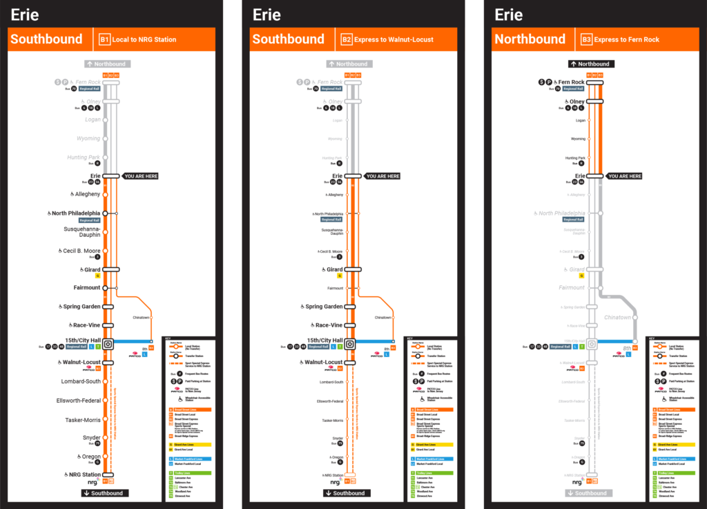
Shown here as an example of the Broad Street Lines, Platform Line Maps could be employed along lines where service patterns are separated architecturally by platform or by track. They may not be required for all lines in the METRO, such as along the T lines where many shelters service multiple service patterns within the line.
Alternate Layout Applied Examples
Existing Conditions

Recommendation

What’s Next?
- Validate recommendations through outreach and continued conversations
- Finalize transit vocabulary decisions to enable expanding the system to design and construction
- Determine station naming conventions and necessary revisions
- Incorporating planned service changes through major capital projects
- Full wayfinding signage system design
- Coordination with other media: audio announcements, website, digital screens, SEPTA app, etc.